Lemland
Lemland | |
|---|---|
Municipality | |
| Lemlands kommun | |
 The medieval parish church in Lemland. | |
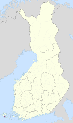
 Location of Lemland in Finland | |
| Coordinates: 60°04.2′N 020°05.2′E / 60.0700°N 20.0867°E | |
| Country | |
| Region | Åland |
| Sub-region | Countryside |
| Government | |
| • Municipal manager | Mikael Smeds |
| Area (2018-01-01)[1] | |
• Total | 965.30 km2 (372.70 sq mi) |
| • Land | 113.21 km2 (43.71 sq mi) |
| • Water | 852.23 km2 (329.05 sq mi) |
| • Rank | 293rd largest in Finland |
| Population (2024-10-31)[2] | |
• Total | 2,140 |
| • Rank | 250th largest in Finland |
| • Density | 18.9/km2 (49/sq mi) |
| Population by native language | |
| • Swedish | 91.3% (official) |
| • Finnish | 3.4% |
| • Others | 5.4% |
| Population by age | |
| • 0 to 14 | 20.6% |
| • 15 to 64 | 61.2% |
| • 65 or older | 18.2% |
| Time zone | UTC+02:00 (EET) |
| • Summer (DST) | UTC+03:00 (EEST) |
| Website | www.lemland.ax |
Lemland is a municipality of Åland, an autonomous territory of Finland.
The municipality has a population of 2,140 (31 October 2024)[2] and covers an area of 965.30 square kilometres (372.70 sq mi) of which 852.23 km2 (329.05 sq mi) is water.[1] The population density is 18.9 inhabitants per square kilometre (49/sq mi).
The municipality is unilingually Swedish.
The Lemström channel divides Lemland from its neighboring municipality, Jomala. It was widened by Russian POWs in 1882.
History
[edit]The church in Lemland was built in the 13th century and has wall paintings from the 14th century.[citation needed] The church is dedicated to Bridget of Sweden.
During the Finnish War in 1808 the Swedish king Gustav IV Adolf had his headquarters in the Lemland parsonage.[5]
Gallery
[edit]-
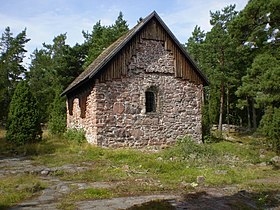
St. Olof's Chapel in Lemland.
-
The Lemström Canal.
-
The Rödhamn Harbour.
-
The Lågskär Lighthouse.
-
The observation tower of Herrö.
Climate
[edit]Lemland has a humid continental climate (Dfb) with oceanic (Cfb) influence
| Climate data for Lemland Nyhamn (1991–2020 normals, extremes 1959- present) | |||||||||||||
|---|---|---|---|---|---|---|---|---|---|---|---|---|---|
| Month | Jan | Feb | Mar | Apr | May | Jun | Jul | Aug | Sep | Oct | Nov | Dec | Year |
| Record high °C (°F) | 8.5 (47.3) |
7.8 (46.0) |
11.1 (52.0) |
16.4 (61.5) |
23.5 (74.3) |
26.5 (79.7) |
28.7 (83.7) |
26.9 (80.4) |
21.4 (70.5) |
16.4 (61.5) |
12.7 (54.9) |
9.3 (48.7) |
28.7 (83.7) |
| Daily mean °C (°F) | 0.2 (32.4) |
−1.1 (30.0) |
0.4 (32.7) |
3.2 (37.8) |
7.7 (45.9) |
12.4 (54.3) |
16.7 (62.1) |
16.9 (62.4) |
13.1 (55.6) |
8.3 (46.9) |
4.6 (40.3) |
2.1 (35.8) |
7.0 (44.6) |
| Record low °C (°F) | −29.2 (−20.6) |
−24.9 (−12.8) |
−17.3 (0.9) |
−12.8 (9.0) |
−1.2 (29.8) |
2.2 (36.0) |
6.4 (43.5) |
4.0 (39.2) |
2.0 (35.6) |
−3.0 (26.6) |
−8.5 (16.7) |
−23.0 (−9.4) |
−29.2 (−20.6) |
| Source 1: FMI climatological normals for Finland 1991-2020[6] | |||||||||||||
| Source 2: Record highs and lows 1959- present[7] | |||||||||||||
References
[edit]- ^ a b "Area of Finnish Municipalities 1.1.2018" (PDF). National Land Survey of Finland. Retrieved 30 January 2018.
- ^ a b c "Finland's preliminary population figure was 5,635,560 at the end of October 2024". Population structure. Statistics Finland. 19 November 2024. ISSN 1797-5395. Retrieved 22 November 2024.
- ^ "Population according to age (1-year) and sex by area and the regional division of each statistical reference year, 2003–2020". StatFin. Statistics Finland. Retrieved 2 May 2021.
- ^ a b "Luettelo kuntien ja seurakuntien tuloveroprosenteista vuonna 2023". Tax Administration of Finland. 14 November 2022. Retrieved 7 May 2023.
- ^ Torsten Hellberg (ed): Åland – mer än öar, p.19. Stockholm 2001.
- ^ "FMI normals 1991-2020". fmi.fi. Retrieved 23 April 2023.
- ^ "FMI open data". FMI. Retrieved 21 May 2023.
External links
[edit]![]() Media related to Lemland at Wikimedia Commons
Media related to Lemland at Wikimedia Commons
- Municipality of Lemland – Official website


